Svalbard's Geography
Svalbard is an archipelago spread in the area between 74° and 81° north and 10° to 35° east. It is almost precisely north from Czech Republic - our home - half the way from Arctic Circle to the North Pole.

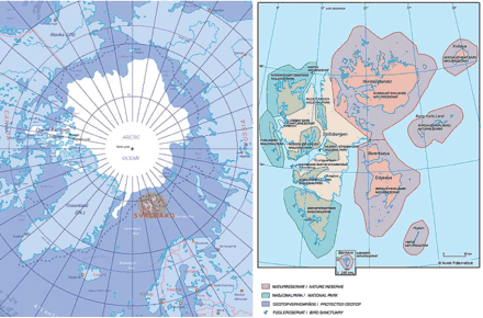
The chart in the left shows location of Svalbard when looking at the globe from the North Pole. The chart on the right has been included to give the basic notion of the shapes of the islands.
Total area of the archipelago is 61200 km2. LArgest islands are Spitzbergen (38000 km2), Nordaustlandet (14500 km2), Edgeoya (5000 km2) a Barentsoya (1300 km2).
For a visitor, the most important part is the area called Nordenskjold Land on the Spitzbergen island. There is the town of Longyearbyen - the administrative center - as well as most of the other settlements, in the area.
